Groundradar’s Jamaican partners have commenced a large mapping project with UltraGPR for karstic bauxite in St. Ann Parish, Jamaica. The project is expected to last at least five months and covers some 400+ hectares of ground at tight grid spacings.
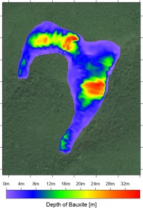
Example of karstic bauxite pit model based on UltraGPR data showing thickness of bauxite